Increasingly intense flooding puts more people in danger than ever.
The Chehalis River Basin Flood Control Zone District (FCZD) is proposing to construct a new flood retention dam and temporary reservoir near the town of Pe Ell, Washington, as well as make improvements to the levee around the Chehalis-Centralia Airport.
The project is intended to reduce damages from major floods from Pe Ell to Centralia triggered by rainfall in the Willapa Hills. (See the Vicinity Map.)
Current Status: In Review
The Washington Department of Ecology and the U.S. Army Corps of Engineers are conducting environmental reviews of the proposed FCZD project under the State Environmental Policy Act (SEPA) and National Environmental Policy Act (NEPA). These respective regulatory reviews will identify probable impacts from the proposed project and proposed mitigation.
View more information about the state and federal reviews:
The Chehalis Basin Board will use the information from the environmental reviews and more to inform their recommendation about whether the project will move forward as part of the Chehalis Basin Strategy. Several options for large-scale flood damage reduction are under consideration, including the Local Actions Non-Dam Alternatives. The Chehalis Basin Board will be making decisions about which projects to move forward once the EIS is finalized.
Who is the FCZD?
The Chehalis River Basin Flood Control Zone District (FCZD) was formed by the Lewis County Board of County Commissioners in reaction to the devastating floods of 2007 and 2009. It is different from the Chehalis Basin Flood Authority and is not part of the Washington Department of Ecology. The FCZD works to make the Chehalis Basin a safer place for communities impacted by flooding.
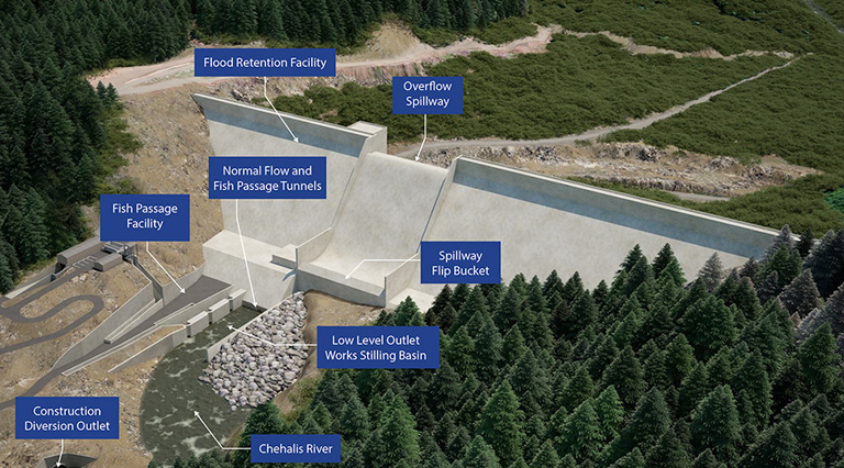
Proposed FCZD Project Components
Dam & Reservoir
The proposed flood retention dam and associated temporary reservoir would be intended to reduce damages during a major flood caused by rainfall in the Willapa Hills. It would not protect all communities from all flooding, nor is it designed to stop regular annual flooding from the Chehalis River. The facility would only store floodwater during major floods and then slowly release the retained water when it is safe to do so and over a period of time. Most of the time, the Chehalis River would flow through the structure’s low-level outlet works at its normal rate of flow and volume—and allow fish to pass upstream and downstream.
View additional details on the Flood Retention Facility – Expandable (FRE).
What’s a “major” flood?
A major flood in the Basin (an event with flows greater than 38,800 cubic feet per second at the Grand Mound gage located along the Chehalis River) currently has a 15% probability of occurring in any given year (an approximate 7-year recurrence interval). With climate change, the frequency of major floods is predicted to increase in the future.
Fish Passage
Fish passage facilities at the dam would be designed to allow fish to pass both upstream and downstream during:
- Construction using a river bypass tunnel
- Normal flows through low-level passageways that would remain open during normal conditions and smaller floods
- Major floods, using a fish collection, handling, transport, and release facility (trap and haul) when the structure’s outlets are closed
View additional details on the Flood Retention Facility Fish Passage.
Airport Levee
The project also includes airport levee improvements to protect the Chehalis-Centralia Airport, local businesses, and area transportation from major flood damage. In addition to raising the existing levee around the Chehalis-Centralia Airport, 1,700 feet of Airport Road would be raised to meet the airport levee height along the airport’s southern extent.
View additional details on the Airport Levee Improvements.
Additional Information
- Chehalis River Basin Flood Control Zone District’s Project Description
- Chehalis River Basin Flood Control Zone District website
- EIS Scoping Meeting Materials
- Proposed Project Description Clarification 113018
- Proposed Project Description Clarification 011419
- Proposed Project Description Clarification 031219
- Proposed Project Description Clarification 031519
- Proposed Project Description Clarification 032219
To view more studies which have informed the proposed dam’s design and evaluation, visit Studies & Publications.